What this is all about...


The idea to drive, photograph and document the gravel mountain passes of the coastal region of South Africa occurred to me while driving the Prince Alfred pass early in 2012. A mountain pass is much more than a cumbersome stretch of road linking the areas on either side of a mountain. There is a "this side", which invariably differs from the "other side", as well as an "inside". Each side containing its own unique collection of marvels. Old classic farm houses, derelict but stylish bridges, missionary churches, rock formations, old toll houses from yester year giving shelter to a squatter ghost or two, succulents hiding in rocky crevices, black eagles scouting for hyraxes and much more. Hopefully there is also a charming campsite somewhere on the "other side" to erect an antenna in time for the 18h00 schedule to share the day's discoveries with the OM and YL's within reach.


The expedition started on 12 September 2012, when we left Durbanville for the Richtersveld. It is not always possible to say where we will be on what day. That is why this an expedition and not a tour.


Die idee om die bergpasse van die kusstreke van Suid-Afrika te verken, te fotografeer en te dokumenteer het ontstaan toe ek vroeg in 2012 oor die Prince Alfredpas gery het. 'n Bergpas is veel meer as 'n lastige stukkie pad wat die areas weerskante van 'n berg met mekaar verbind. Daar is 'n "hierdie kant", wat sonder uitsondering baie anders is as die "ander kant", en natuurlik ook 'n "binnekant". Elke kant bring sy kant met 'n unieke versameling interessanthede. Ou klassieke plaashuise, verlate maar stylvolle brue, sendingkerke, rotsformasies, tolhuise van eergister wat die spook of twee wat daar kom plak het teen die elemente beskerm, vetplante in rotsskeure, witkruisarende op soek na dassies, en veel meer. Hopelik ook 'n oulike kampterrein aan die "ander kant" waar ek 'n antenna kan opslaan, betyds vir die 18h00 skedule om die dag se ondekkings te deel met die OM'e en YL's binne bereik.


Die ekspedisie het op 12 September 2012 bgin toe ons Durbanville verlaat het oppad na die Richtersveld. Ons moet maar steeds sien waar ons wanneer sal wees. Dit is waarom dit 'n ekspedisie is en nie 'n toer nie.

Monday 18 February 2013

At last, the promised (and penultimate) update of Phase 2.

While at Maclear we learned that the Venters could no longer join us for the Wild Coast leg of the expedition.  Port St Johns had been at the back of our minds and we changed course in that direction.  The trip from Maclear via Ugie and Mtatha is on a good tar road and is not very "expedition-like".  The scenery remained idyllic. We had been told by the locals that driving the Lilangeni pass is like a "journey on top of a forest". It was very scenic but the fact that the road is tarred spoiled the magic.

I did not know what to expect of the Transkei coast. I had actually assumed that the passes aspect of the journey would be over once we moved towards the coast.  The truth is that the coastal roads form a network of mountain routes. It felt like one very long mountain pass. Whether that is technically correct is open for debate. I must still make up my mind about the definition of a mountain pass.


The Transkei Wild Coast is a mountainous piece of earth. Unlike the West Coast where the land flattens out into wide coastal plains, the mountains of the Wild Coast meet the sea head on, in a more dramatic way than at the Cape south coast. Transkei and Lesotho must be the two most uneven countries in the world - from a dumpy level perspective. Port St Johns is situated at the Umzimvubu River mouth (above). The town itself is dirty and unattractive but the environment is stunning. The main tourist activity is angling. One gets the impression that the Wild Coast attracts its share of weirdos from the white population. Middle aged men with grey pony tails and heavily tanned women with dirty feet doing yoga at sunset while facing the sea from a hill.


We stayed one night at the Cremorne Resort a few kilometers from Port St Johns. It is a lovely resort that is well maintained. The restaurant serves a mean Dorado at a reasonable price.


The direct route from Port St Johns is not a 4x4 route but it is rough. Sedan cars do not belong here. The most popular vehicle of the locals is the Toyota Hilux pickup from the 80's.
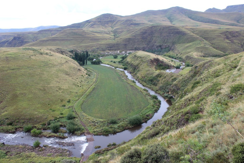
The population density is high and the picture above gives a good idea of what the whole area looks like. A passionate photographer would take a long time to travel down the coast. The 108 kilometers from Port St Johns to Coffee Bay took us just under four hours.


The top of the rondawel huts look a bit weird. The thatch reed is "locked" at the top by an old tyre that is placed over it. The tyre is filled with clay (as a sealant) with slivers of stone, glass, sea shells, etc stuck into the clay. Apparently these objects serve three purposes: decoration, reinforcing the clay and keeping owls off the roof. A hooting owl on the roof is a bad omen.


We all fall together.


A Transkei road block. The cattle are very reluctant to give way to vehicles. Often the Hiluxes would weave through the cattle at high speed, missing the animals by inches. We came across a donkey foal with its hind leg broken and almost severed at the hoof, lying at the edge of the road. It was probably struck by a passing vehicle. The hanging ears and the general appearance of the foal indicated a dying animal. I took a photograph but did not want to publish it here. The next day the foal was gone. Hopefully it had died or had been killed by its owners.


Coffee Bay is close to the famous Hole in the Wall. The little black spot in the wave right in the middle of the Hole is the head of a local youngster. He swam out, allowed himself to be sucked out by the current and then body surfed back on the next big wave. He clearly knew what he was doing.  We took the pink option of staying in a chalet at White Clay just outside Coffee Bay. To be recommended, especially as we bought crayfish at R20 a piece.


The last camp of Phase 2 at Morgan Bay at the Transkei border close to Kei Mouth. Very good camp site with reasonable rates. We arrived via the N2 from Coffee Bay and again had to face the suicidal South African drivers. The Transkei variety is particularly reckless.


 The ferry at Kei Mouth is one of three of its kind in South Africa. The other two are at the Breede River and Sendelings Drift (Orange River).

The next day we drove to Storms River Mouth and on Friday we arrived home. Safe and sound.

In the last post of this phase (later this week) I will summarise the trip and give our impressions. The next phase involves the passes of Lesotho and Natal.


Sunday 10 February 2013

Ek wil graag vir die taalvegters noem dat dit nogal harde werk is om alles tweetalig te doen. Aangesien daar'n groot aantal van die volgers is wat glad nie Afrikaans magtig is nie, skryf ek die blog dus nou hoofsaaklik in Engels.

Just like Hogsback, Rhodes is a little gem in the mountains. When we arrived via Joubert Pass, the weather was still ok, but later on we cherished our choice of accommodation.  It rained intermittendly through the night. Early Sunday morning we left for Maclear.


Just like Swartberg Pass, Naudesnek is one of the all time greats. Definitely in the top 5. It is long and steep, and impassable when it snows, which is every winter. But the main benefit for the traveller is the scenery. One piece of magic after the other. In the photo above we are still climbing to the neck. About 2580 meter above sea level. The road surface was wet but not too bad for a four wheel drive vehicle.


Ranging from plain scenic to dramatic. One would assume that autumn's pastel colours would be equally impressive.


After Naudes Nek, we met with Potriviers Pass which was less dramatic but nevertheless scenic and slippery. A large number of Amur Falcons sat on the electric wires. They mainly prey on insects.

At about midday we arrived in Maclear. There was no good camping site close by and we opted for a cottage for the second day in a row. If the weather clears sufficiently it will be back to the tent from tomorrow or Tuesday.

The electricity in the air made radio contact almost impossible during the past two days. This afternoon I managed a 30 second chat with ZS1TR. Hopefully that will improve from tomorrow.

Tomorrow we turn south towards Elliot, Stutterheim and so forth and hope to be in Morgan Bay by Tuesday night.

Saturday 9 February 2013

Since the last post we had left Knysna, travelled from Hogsback to Lady Grey and then on to Rhodes. Updating the blog has been difficult as the internet speed in the deep country is very slow. Often the link failed before one got going. Hopefully tonight will work.


One of the hogs of Hogsback. The photo was taken from the Swallow Tail camp site where we stayed for two nights. The facilities included a large room with an indoor barbeque where we could cook our
meals. Hogsback is a kind of a medieval England in the mountains of South Africa. A serious English country feeing to the place but almost everyone speaks Afrikaans.


The photograph above reminded us a bit of Austria. It was taken from half way up Katberg Pass. Officially the pass is a public road. In reality it would be difficult to travel it in a 2x4 vehicle. It is long and steep with lots of flood damage. Eventually we arrived at Sada and then turned back for our last night in Hogsback.


En route back to Hogsback we encountered lots and lots and lots of picture perfect scenes like the one above.
As the weather was good, I had very good radio contacts with Trevor in Bredasdorp and Rayne in Hermanus later that afternoon.


Yesterday morning we packed and took the route to Queenstown (first visit), Dortdrecht (first visit)
and Lady Grey (first visit). After a bit of a search we found the camp site of Karnemelkspruit River Resort. Both the Caravan magazine and Tracks4Africa provided the wrong coordinates. Between Dordrecht and Lady Grey we covered a few smaller but picturesque passes. One of them led to this scene of the bridge over the the Waboom River (above).


The town of Lady Grey is typical of the Eastern Cape countryside. Many English names, and a bit run down, but with lots of character. The Jouberts Pass is a steep and very scenic pass leading to the tar road to Barkly East. The picture above shows Lady Grey from quite high up. At the top of the pass one is 2241 metres above sea level.


A photograph seldom does justice to the pass itself. but here is a glimpse of Joubert Pass.


The route from Barkly East to Rhodes produces a lot of scenes like this one. After arriving in Rhodes we had quick beer at the hotel and then found accommodation in a self catering set up. It paid dividends as an hour later we were entertained by a thunderstorm. Sadly I could not erect the antenna to participate in the Radio League's Field Day. Weather permitting we will tackle Naudes Neck tomorrow.

Tuesday 5 February 2013


A camp can also look like this. A wet day in the southern Cape "forced" me into this log cabin at the Sanparks resort near Wilderness. For my daily radio schedule I erected the 8 foot whip attached to the roof rack, taped a 20m steel wire to the tip with a weight at the other end of the wire and threw the weighted end over the tree in the picture. It worked well but the next morning I forgot about it and drove off, almost taking the tree with me.


In an effort to rectify the previous day's mishap with the camera's SD card, I retraced my steps and drove the Montague Pass again, in the opposite direction. Lovely pass full of history.

Ek moes maar weer die Montaguepas op om die vorige dag se mistykie met die kamera reg te stel. Baie mooi pas, vol geskiedenis.  


As mens amper bo-op die berg is kom jy op hierdie bewys af dat 'n "binnebraai" selfs in die ou dae amper belangriker as die huis was. Stewig gebou en bedoel om die huis te oorleef.

Close to the top of the pass is this relic showing the importance of an "indoor barbeque", even in the old days. Designed to survive the house. :-)


Nobody said you had to be creative to name a shop or a butchery. (Nasionale Pad = National Road)

From the top of Montague Pass I followed the national road east and then took the gravel turn off to the tine settlement De Vlugt where the road joins the Prince Alfred Pass. The pass was wet and  bit slippery but I met a number of sedan cars along the way. The highlight of the day was a crowned eagle that crossed the track in front of me, banking and then settled in a tree about 50 metres away. He flew off before I could take a photo. They are scarce and endangered and this was my second sighting of one in the wild. They prey on monkeys regularly and are powerful enough to take young duiker (antelope) and even bosbok (antelope).  

Now at Brenton-on-Lake campsite. Good weather. Waiting for the missus to arrive by bus at 14h00. Then we will drive the Seven Passes route to George before returning to Brenton for a pan fried Gunnard, mash and veggies. Tomorrow we hope to get close to Fort Beaufort in the real Eastern Cape. New territory for me.

Sunday 3 February 2013

Going down Montague Pass this morning  :-)


Photo: The beginning!
This morning I left Katot Meyer's camp site in Oudtshoorn just when the rain started. During my stay I discovered that his wife Ilse also has a thing for mountain passes. The music that I had referred to in an earlier post was an all night fund raising event for cancer treatment. Very loud devil music with the DJ's voice in between. I tried to make ear plugs from toilet paper. They did not help at all and I even battled to get one of them out of my ear.

By the time I was out of Oudtshoorn it was pouring "nicely". The descent down the historic Montague pass was exciting with cascading waterfalls all around me. I took a number of dramatic photographs but later on discovered that there was no SD card in the camera.

In view of the weather I took the pink option to book into a chalet at Sanparks campsite outside Wilderness. The weather man says the next few days will be sunny in this area. If he is correct I will go back up the Montague Pass tomorrow (for photos), then eastwards direction Avontuur, turning south to Knysna via Prince Alfreds Pass.

The statistics of the blog's viewers are interesting. Since the start of the blog the top ten countries are as follows: (note that the number of views do not equal the number of different viewers - the same viewer can have many views)

RSA              1473
USA                  52
Netherlands        51
Russia                37
Australia             28
Ukraine               25
Namibia              22
UK                     17
Germany             16
Latvia                 16

Also a few views from other countries, eg Ghana and Botswana.

I suspect that some of the viewers are hams who have picked up the link on the SA Radio League's website. It would seem that there is a viewer in the Ukraine who is following the blog consistently. It would be very interesting to hear from some of the very far away viewers. I am comfortable with any contact in Afrikaans, Dutch, English and German. My Russian, Ukrainian and Latvian vocabularies are limited to the words vodka and milota.

Saturday 2 February 2013


Baie oulike roete gery vandag. Nooit gedink daar is so baie agterpaaie naby die Kaap wat ek nie ken. Van Oudtshoorn met die ou pad langs die R62 tot by De Hoop (foto van kerk), oor die Rooibergpas na Van Wyksdorp (foto van mall) en met Cloetespas na Herbertsdale en Mosselbaai vir 'n lekker Dorado en chips in die hawe. Nou terug in Oudtshoorn en wag vir hoender en groentepot om gaar te word. Mooi radiokontakte gisteraand en vanaand. Soos altyd Trevor uit Agulhas en vanaand ook Paul v Spronsen van sy kampplek in die Biedouwvallei. Ek is gedwing om te luister na musiekshow op sportgrond vanaand. Kunstenares sonder talent - so Idolstipe. 

Followed a scenic route today from Oudtshoorn via de Hoop (church), over Rooibergpas to Van Wyksdorp (mall), over Cloetespas to Mossel Bay for a Dorado and chips in the harbour. Back in Oudtshoorn, waiting for chicken and veggie pot to cook. Good radio contacts last night and tonight. As always Trevor from Agulhas and tonight also Paul van Spronsen from his camp site in Biedouwvallei. The church below is almost in the veld - not many buildings in the area.


Friday 1 February 2013

O ja, vergeet om te vertel. Die eerste nag in Montagu word ek wakker van iets groterig wat teen my hand wil opklim. Dis donker en ek dink dit kan net 'n groot spinnekop wees en hulle is nie giftig. Ek slkud hom af en slaap verder. Volgende oggend sien ek daar is 'n padda in die tent. Moes vorige aand toe flap oop was ingeklim het.

I forgot to mention that during the first night in Montagu I was woken by something trying to climb onto my hand. I thought it was a large spider and as they are not poisonous, shook it off and slept further. Next morning I discovered a frog in the tent. Must have entered the previous night when the flap was still open.
Die kort pad deur die plase van Sandrivier na Prins Albert word toe 'n lang pad. Vir die tweede keer op hierdie ekspedisie moes ek voor 'n vol rivier swig. Dit las toe so 70km by die dag se ryery. "Life is tough". Dit was die Dwykarivier wat uit die Moordenaarskaroo kom en uiteindelik deur Die Hel vloei.

A flooded river turned me back for the second time on this expedition. It added 70km to the day's driving.


Swartbergpas must be one of the top 5 in the country.


Die Otto du Plessispad (eintlik pas) is rof met dramatiese tonele en eindig in 'n redelike ongemaklike steil pas. Die Defender se wye draaisirkel dwing mens om twee keer 'n drie punt draai te maak by die haarnaalddraaie.

The Otto du Plessis road which links Swartberg Pass with Die Hel, is long and rough but with dramatic scenery. The final descent into Die Hel is very steep with tight hair pin bends.


Dis hoe Die Hel van buite lyk. Toe hulle nog daar geboer het was dit landerye. Die doringbosse het later oorgeneem. Dis moeilik om met 'n standaard mobiele HF antenna (vertikaal of V) 'n goeie sein hier uit te kry, veral as die weer nie saamspeel nie.

Die Hel from the top of the pass. In the old days the view showed cultivated fields. The thorn trees are more recent (past 30 years) invaders. HF signals do not travel well out of the kloof.


Swartbergpas kan ook so lyk. Oppad Oudsthoorn toe in mis en reen.

A different Swartbergpas. En route to Oudtshoorn.


From Montagu I took the road to Anysberg via Oubergpas (not the one close to Sutherland :-) ). Drove through the reserve, past Floriskraaldam towards Bosch Luys Kloof (original spelling?). The first photo shows the pass with glimpses of Floriskraaldam in the deep background. Lovely pass. Accommodation in the reserve is rather expensive. Access to the dam (and cheaper accommodation) blocked by locked boom.

Drove back up and camped at Sandrivier farm on rocky ground under blue gums. Lots of thunder and lightning that evening. Had to take antenna down. Did not not want to get tanned by a lightning bolt.


Dwergarend  (booted eagle) wat bo-oor Montagu gevlieg het. Daar is 'n klein suidelike populasie wat oorwinter in SA. Al 'n paar keer naby De Doorns gesien. As Sinterklaas vir my 'n langer lens wil bring kan ek beter fotos van sulke "sightings" neem.

Booted eagle flying over Montagu. Small southern poulation that tends to over winter in SA. I have seen them on occasion in the De Doorns area.

Monday 28 January 2013

The idea was to sleep in the Anysberg Reserve tonight. Good thing that I phoned before I left the Cape. No camping there until the ablutions have been built/restored/fixed.
Therefore I am sitting in a lovely spot in the Montagu Caravan Park. I have pitched my tent (2 seconds) and repacked everything, went for a swim, and am waiting for 18h00 for the first radio schedule. Ja, and I am pretty sure a booted eagle passed overhead. Photo to follow. The route tomorrow is through Anysberg towards Bosluiskloof. Not sure where I will sleep. Maybe Ladismith. Having rib eye steak tonight.

Die idee was om vanaand in die Anysberg Reservaat te slaap. Gelukkig het ek eers gebel. Ablusies steeds onder konstruksie.
Ek sit in die Montagu Karavaanpark. Warm maar genoeg skaduwee. My tent was binne2 sekondes op en alles is oorgepak en geherorganiseer. Wag nou vir 18h00 radioskedule. Ek is ook seker ek het 'n dwergarend bo-oor sien vlieg. Foto volg. Die roete more is deur die Anysberg Reservaat, rigting Bosluiskloof. Weet nie waar ek more slaap nie. Miskien Ladismith. Eet vanaand rib-eye steak.

Wednesday 9 January 2013

Teen einde Januarie behoort die blog weer aktief te wees. Die plan is om so oor twee weke weer die pad te vat met Fase 2 van die ekpedisie. Die keer is die Suid Kaap en die Oos Kaap aan die beurt. Tot dan ...

By the end of January this blog should be active again with Phase 2 of the expedition underway. The Southern Cape and Eastern Cape are on the cards. Until then ....